
In terms of transport geography, accessibility is defined as:
“the measure of the capacity of a location to be reached from, or to be reached by, different locations.”
This definition implies that distances between locations vary and therefore some locations are less accessible than others.
A common less accessible location is one that is furthest from a coastline. Known as a pole of inaccessibility (PIA), the concept was first introduced by Vilhjalmur Stefansson in 1920 to distinguish between the North Pole and the most difficult-to reach place in the Arctic. Scotland also has a PIA.
Other less accessible locations are those furthest from where people live. In Scotland, the majority of people live in one of 519 settlements defined by the National Records of Scotland (NRS) as:
“built-up areas which round to 500 people or more, with larger settlements divided into localities to reflect areas which are more easily identifiable as the towns and cities of Scotland.”
The maps below explore the less accessible locations from Scotland’s settlements and localities.
Distance ‘as the crow flies’
The simplest measure of accessibility is the euclidean distance, better known as the distance ‘as the crow flies’. The map below shows these distances as simple concentric circles spreading out from settlements and localities.

Sometimes the least accessible location is derived using voronoi vertices. However, as also shown in the map above, this can be incorrect when the point occurs close to the edge of the area in question.
Visit Scotland has useful information on visiting North Rona, Fair Isles, St Kilda, Cape Wrath, Barra, Mingulay and Pabbay. Information on visiting the Flannan Isles is also available.
Friction of distance and travel time
The problem with euclidean distances is that they do not take into account the cost/effort of movement, known as the friction of distance. The locations with the most accumulated friction relative to others are likely to be the less accessible and their distances are often measured in travel time.
Land-based travel walking-only speed without access to motorized transport
In 2019, the Malaria Atlas Project (MAP) produced a global friction/cost surface that takes into account surface attributes (i.e. roads, railways, rivers, lakes, seas, slope, elevation, and landcover type) to assign a value to each 30 arc second square across the world representing the friction/cost of land-based travel walking-only speed without access to motorized transport.
The map below uses this global friction/cost surface and example R code to derive a different view of the less accessible locations in Scotland.

Highlighted areas are named according to their inter zones.
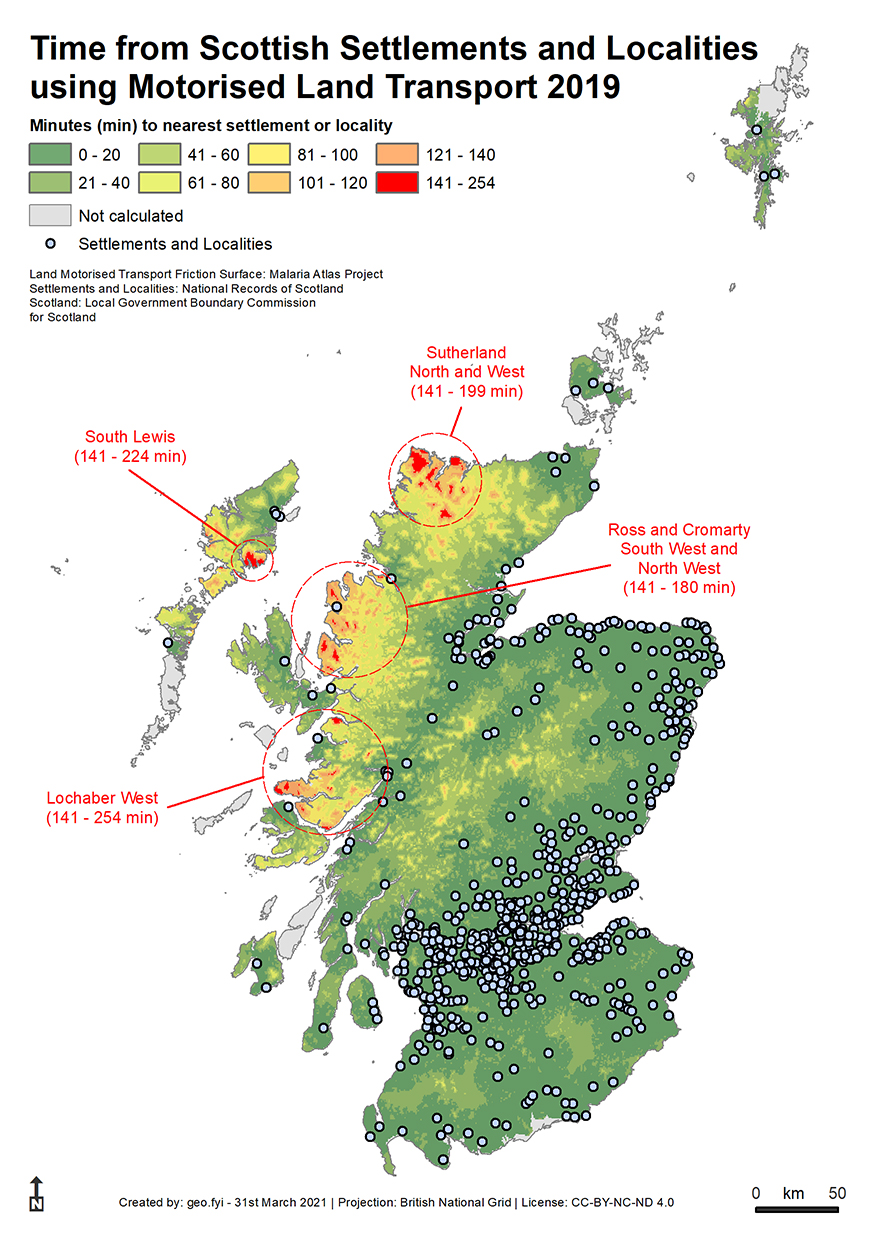
Land-based travel speed with access to motorized transport
MAP’s global friction/cost surface also has values representing the friction/cost of land-based travel speed with access to motorized transport (although the term motorized transport is not defined).
The map below shows a different view again of the less accessible locations in Scotland with the simple concentric circles disappearing and a more complex pattern emerging.
Limitations
The limitations of using the two friction surfaces above are:
– The friction surface has no knowledge of pathways, access rights, local habitats, weather/surface conditions and time of day/year travelled.
– The results do not take account of real life concerns like the ability to move constantly, fitness/state of repair, changing transport methods or the practicalities/difficulties of moving up mountains.
– The code brings its own artefacts to the results. Other cost-distance tools and approaches are available.
– The classification choices affect what is highlighted and what is not. For each map (including the ‘as the crow flies’ map) the histograms of values was examined and the classification chosen to best represent their distribution using familiar units i.e 10 km and multiples of 20 mins whilst keeping to eight classes.

Despite the limitations of all the methods employed, some insight is gleaned into what are the less accessible locations from Scotland’s settlements and localities.
