
As a contribution to Geography Awareness Week, I’m publishing something I wrote over twenty years a go in 1997. It may still be of interest and value.
Introduction
“I demand true maps, as soon as can be.” – General Mirov
Watson, I (1992 p.28)
“Don’t you realise? Our maps are all lies! Deliberate lies, distortions. In the department of cartography our main brief is to warp the true shape of our country in all sorts of subtle ways.” – Peterkin
Watson, I (1992, p.22)
Until recently, the scientific model of cartographic communication has been dominant in cartography. The beginnings of this model were in the early 20th century when Eckert (1908 p.4) accorded the main purpose of maps with the “transmission and dissemination of scientific truths”.
Much later, in the 1960s and 70s, far more work began on the scientific model (Imhof, 1963; Board, 1967; Koláncý, 1969; Guelke, 1973; Ratajski, 1973; Salichtchev, 1973; Petchenick, 1975 and Robinson and Petchenick, 1975). This work was based upon the scientific model of communication (Figure 1).

In using this model, these cartographers saw the purpose of the map as the presentation of
“objective information about reality conceived in spatial relations, in a true and telling way”
(Koláncý, 1969 p.40)
In effect, a map is seen as an accurate representation of reality as free as possible from error.
The scientific aspect of cartography was broken down into theoretical and technological, the former relating to psychology and perception in that all observation is inventive (Petchenick, 1975), and the latter relating to map construction or ‘cartology’ (Ratajski, 1973).
Both were considered applied and technical sciences incorporating an artistic trend (Imhof, 1963). The problem of noise was considered a part of the inefficiency of the layout and content of the map, something which could be improved by studying symbol design, user perception, map production etc. Any subjectivity was due to differences between reality as perceived by the map maker and by the map user.
“[This subjective noise] is caused not by the subjectivity of the information or its perception but by the different degree of extraction of information; this depends primarily upon the schooling – practical, academic, methodological, and ideological – of the map reader”
(Salichtchev, 1973 p.112)
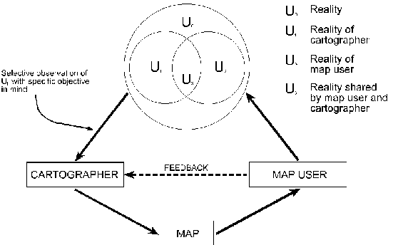
However, authors differed in their descriptions of the subjective. Some, such as Koláncý (1969), noted that the cartographer’s reality is a selective observation, one which was capable of transforming the users opinion of reality (Figure 2).
Ideology and the subjective
When designing any map, an approach based upon the scientific model of communication pays great attention to functionality of design and concerns of technological implementation (Huffman, 1996), its goal being objectivity. This approach has given cartography what Harley (1990 p.10) called “a status of sub-science”, something cartography needed earlier in the century to gain acceptance as an independent discipline.
However, both through content and method of representation, cartography is soaked in ideology (Harley, 1988 and Crampton, 1994). Ideological distortion rather than scientific integrity should therefore be the focus of any debate concerning the apparent objectivity of maps (Harley, 1988), recognising that
“in some instances cartographic accuracy may actually take second place to ideological considerations”
(Vujakovic, 1988 p. 11)
Ideology, like noise, distorts. However, within scientific communication theory, noise is seen as a purely technical problem between the map maker and the map user. A problem which can be overcome by technological progress, producing a more precise scientific representation of reality (Harley, 1989).
Using the three elements of design theory drawn up by Buchanan (1989), it can be seen that a purely scientific approach to cartographic design results in the technological and functional aspect, which Buchanan (1989) calls logos, dominating over other aspects of allure/credibility (ethos) and emotional stimulation (pathos).
The resultant maps are striving for a precise and absolute appearance which reinforces their scientific credentials of being objective (Wright, 1942), masking subjectivity, ethos and pathos behind objectivity and logos (Buchanan, 1989). However, it may be argued that maps contain both objective and subjective realities (Wright, 1942), the latter often being determined by an ideology.
However much the functional or technical side of cartographic communication is fine-tuned, the subjective element can never be removed. Ideology is a central (Crampton, 1994) and unavoidable (Torok, 1993) aspect of cartography, which serves to
“organise the world according to a certain sense of space and an evaluation of what is important”
(Harley, 1990 p.5)
and is dependent on the subjective. Each individual map is therefore just one of many ways of looking at the world (Harley, 1989).
Cartographic representation, knowledge and power
A prominent characteristic of maps, irrespective of cartographic communication theory, has always been how map users tend to see maps as objective and factual, as representing the truth (Coulson, 1977). However,
“truth after all is no more inherent in the graphic image than in the written or spoken word”
(Coulson, p.107)
One is brought up to question the motives and rhetoric behind words but not, it seems, behind the map. Maps, like words, are made by people and, like a person, speak “clearly and convincingly on a subject of which his knowledge is imperfect” (Wright, 1942 p.8).
However, there is a manifest difference between words and maps. The imperfection mentioned by Wright (1942) is not so much one of imperfect knowledge but one of an imperfect method of representing knowledge. Imperfect representations, the inevitable consequence of not being able to have a 1:1 scale map of the world or representing the three dimensional sphere on a two-dimensional surface without distortion, originate from cartographic procedures such as generalisation, selection, classification, symbolisation and choice of projection.
Primarily, it is their functional imperfection which gives rise to any imperfection in knowledge on the map and is an unintentional, unconscious act (Harley, 1989). However, when these same procedures are used intentionally to distort or add bias, knowledge, as represented by content, becomes more important than cartographic technique (Harley and Zandvliet, 1992).
“Both in the selectivity of their content and in their signs and styles of representation, maps are a way of conceiving, articulating and structuring the human world which is biased towards, promoted by, and exerts influence upon particular sets of social relations”
(Wolff, 1981 in Harley, 1988 p.278)
In this way ideology can express itself through the map and control the representation of knowledge. The 17th century philosopher Francis Bacon observed that knowledge is power and Harley recognised that
“representation is ineluctably a form a power”
Harley (1990 p.12)
and that maps were examples of a power-knowledge relationship “caught up in a wider political context”. Maps pretend to reflect the real world and to be objective. In fact, through the selective representation of knowledge they have the power to determine reality (Dahl, 1992 and Harley and Zandvliet, 1992) as perceived by individual users or by society as a whole, especially in terms of claims to territorial ownership (Figure 3).

Social cartography
Taking into account the above ideas concerning ideology and power within cartographic communication, what then of the bias, distortion, deviance and the abuse of cartographic principles which Harley (1988) refers to? What are their political implications, what do they represent and what are their social consequences?
A theory based upon cartography in a social context attempts to answer this by searching for the
“social forces that have structured cartography” and locating “the presence of power – and its effects – in all map knowledge”
(Harley, 1989 p.2)
Maps are thus recognised as socially constructed artefacts, a point ignored by the proponents of the scientific model of cartographic communication (Harley, 1990). They are “an image of social order” as well as a measurement of objects (Harley, 1989 p.7).
Cartography and the powerful in society
Cartography is not neutral and is in no way separate from the power relations of society (Edney, 1993). Maps can be used to serve particular interests (Wood, 1992a) and, in terms of use by those powerful in society, have become instrumental in
“defining social relationships, sustaining social rules, and strengthening social values”
(Harley, 1989 p.7)
They therefore actively produce ‘culture’ (Crampton, 1994) and draw the boundaries inside which society lives (Harley, 1990). In effect they are “marching orders, commandments, injunctions, decrees”, a tool of control (Wood, 1992b p.67). They involve both the collation of information relevant to control of the conduct of a population and the direct supervision of that conduct (Harley, 1988).
It must be emphasised that this is not a conspiracy theory. Rather it is a recognition that maps are neither, as Wright (1942) noted, wholly objective nor wholly non-objective. The point being that in the hands of the powerful in society there is potential for misuse and abuse, be it malevolent or benevolent. Hence society is open to manipulation by maps as well as benefiting from them with or without an external agenda (Harley, 1988).
Political power is the most familiar sense of power in cartography. This power is external to the map and exerts control through the map (Harley, 1989). Pre-World War Two German propaganda maps are good examples of an external power deliberately distorting the representation of knowledge so as to serve an interest. In this case the interest is to
“form public opinion and build public morale”
(Wright, 1942 p.8)
Figure 4 shows a map used to communicate misinformation, exaggerating claims to cajole a population into justifying war. But what of peace time? It is still important to understand the nature of maps in a social and political context today and be aware of the way they form public opinion.

The power of silence
“I know what ‘dead ground’ means. That merely refers to areas you can’t see on a relief map from a particular view point.” – Grusha
“Such a view point of the State…?” – Valentin
Watson, I (1992 p.16)
An inevitable consequence of cartographic procedures is that some elements of the landscape are left out and others are exaggerated, consciously or unwittingly (Dahl, 1992). Within social cartography, where content is seen as more important then procedure (Harley and Zandvliet, 1992), the inference is that the more prominently an element is represented the more important it is to any external power influencing the map and vice versa (Harley, 1989). The result is that the map is given an internal power to determine a reality dictated by a power external to it.
Through both external and internal factors therefore, maps have as much social influence through omission as through representation. (Harley 1988 p.290 and p.288) considered this “central to any argument about the influence of their hidden political messages”, the influence here being to “discourage the clarification of social alternatives”. Any minority group whose interest is not represented on a map will find it difficult to locate the source of their unease (Harley, 1988).
Here, the resultant silences of the selective representation of knowledge can be viewed as statements of affirmation as to the insignificance or unimportance of particular features (Harley, 1990). The map user therefore reads a distorted view of reality which in the most extreme case supports a particular ideological agenda, helping to carve out a particular public opinion or enforce social control.
Minorities, pressure groups and cartography
Prior to the availability of cheap and powerful personal computers, map making had remained almost exclusively in the realm of large powerful institutions such as businesses and government (Harley, 1990). It has been primarily their ideology and world view which has been reflected in the map.
“The ideological arrows have tended to fly largely in one direction, from the more powerful to the weaker in society”
(Harley, 1988 p.300)
However, the spread of computer technologies through society has meant that maps can be made by more and more people, reflecting many different view points. In this way map making is available to everyone as a medium through which to communicate a point of view (Huffman, 1996), enabling ideological arrows to fly in the opposite direction.
From his confrontational perspective, Wood (1992b p.66) sees the map as “a weapon in the fight for social dominion”, one which minorities and pressure groups can use to readdress the potentially biased representation of reality, using the power of maps to “fight the good fight” (Wood, 1992b p.67) bringing into existence previously unrecognised features of the landscape.
New obligations
Proponents of social cartography are having a great influence on modern cartographic communication theory:
“… the discipline [cartography] will be increasingly enhanced by the recognition of social and cultural consequences of mapping and by the need to examine more carefully a whole range of social questions relating to cartography in its social context both within and between different societies”.
Frazor Taylor: 15th Congress of the International Cartographic Society in Bournemouth, UK, 1991. (In Dahl, 1992 p.62)
This statement recognises that a substantial element of cartography is influenced by the power relations within society, which dominate over concerns of scientific theory or public usefulness (Dahl, 1992).
Within this theory cartographic pretensions to socio-political neutrality are rejected (Harley, 1989 and Belyea, 1992b) and ideological influence is unearthed. Knowing more about the socio-political context of cartography therefore allows the cartographer to have more control over the influence of a map (Torok, 1993). The question for cartography to face here is how are cartographers going to use this control? What are their responsibilities and obligations?
Influencing social change: blueprints for the future
Whilst investigating historical maps, Harley noted that
“maps may be regarded as an agent of change in history”
(Harley, 1988 p.304)
This is equally true today, without our being aware, maps often reinforce and legitimise the status quo (Harley, 1989), but this need not be the case.
“Maps are not confined to the representation of a given state of affairs. They can be drawn to symbolise changes, or as blueprints of the future”
(Speier, 1941 in Wright, 1942)
This then, is the new responsibility of cartography in the light of a social theory.
“[Cartography must] exercise power to protect and enrich human values”
(Torok, 1993 p.10)
It must be “responsive to social issues such as those relating to the environment, poverty, or to the way in which the rights and cultures of minorities are represented” (Harley, 1990 p.2) and “take place more because of public benefit and usefulness and democracy than it has in the past” (Dahl, 1992 p.65).
In effect cartographers must realise and question the ideology behind all of their mapping activities and eliminate, reduce or qualify it, removing unthinking compliance (Belyea, 1992b).
Furthermore, they must also produce new products which challenge the accepted view of reality, filling in the silences on the map. This has often been left to those outside professional cartography (Harley, 1990), but the effect will be the same, enabling people to make informed decisions about the world from a diverse selection of differing view points and “participate and share in defining their futures” (Dahl, 1992 p.65).
“[maps are] active participants in society, not just passive records”
(Crampton. 1993 p.3)
References
Belyea, B. (1992b). Review Article of Dennis Wood’s The Power of Maps and the Author’s Reply. Cartographica Vol. 29, Nos. 3 and 4. 94-99.
Board, C. (1967). Maps as Models in Models in Geography. Chorley, R.J and Haggett, P.(Eds.). Methuen, London.
Buchanan, R. (1989). Declaration by Design: Rhetoric, Argument and Demonstration in Design Practice in Design Discourse: History, Theory, Criticism. Margolin, V. (Ed.). The University of Chicago Press. Chicago. 35-54.
Coulson. M.R.C. (1977). Political Truth and the Graphic Image. The Canadian Cartographer Vol. 14, No. 2. 101-111.
Crampton, J. (1993). In Search of a Language of Rhetoric: Harley and the Ideologies of Maps. Unpublished article. University of Portsmouth.
Crampton, J. (1994). Cartography’s Defining Moment: The Peters Projection Controversy, 1974-1990. Cartographica Vol. 31, No. 4. 16-32.
Dahl, E.D. (1992). Commentary: Brian Harley’s Influence on Modern Cartography. Cartographica Vol. 29, No. 2. 62- 65.
Eckert, M. (1908). On the Nature of Maps and Map Logic. Bulletin of the American Geographical Society Vol. 40. 344-351. Reprinted in Cartographica, Monograph 19 1977, The Nature of Cartographic Communication. 1-7.
Edney, M.H. (1993). The Patronage of Science and the Creation of Imperial Space: The British Mapping of India, 1799-1843. Cartographica Vol. 30, No. 1. Monograph 44. 61-67.
Guelke, L. (1973). Cartographic Communication and Geographic Understanding. The Canadian Cartographer Vol. 13. No. 2. 107-122. Reprinted in Cartographica, Monograph 19 1977, The Nature of Cartographic Communication. 129-145.
Harley, J.B. (1988). Maps, Knowledge and Power in The Iconography of Landscape. Cosgrove, D. and Daniels, S. (Eds.). Cambridge University Press. Cambridge, UK.
Harley, J.B. (1989). Deconstructing the Map. Cartographica Vol. 26, No. 2. 1-20.
Harley, J.B. (1990). Cartography, Ethics and Social Theory. Cartographica Vol. 27, No. 2. 1-23.
Harley, J.B. and Zandvliet, K. (1992). Art, Science, and Power in Sixteenth-Century Dutch Cartography. Cartographica Vol. 29, No. 2. 10-19.
Huffman, N.H. (1996).You Can’t Get Here from There: Reconstructing the Relevancy of Design in Postmodernism in Cartographic Design in Theoretical and Practical Perspectives. Wood, C.H. and Keller, C.P. (Eds.). John Wiley and Sons, Chichester.
Imhof, E. (1963). Task and Methods of Theoretical Cartography. International Year Book for Cartography. Reprinted in Cartographica, Monograph 19 1977, The Nature of Cartographic Communication. 26-38.
Koláncý, A. (1969). Cartographic Information-A Fundamental Concept and Term in Modern Cartography. The Cartographic Journal Vol. 6. 47-49. Reprinted in Cartographica, Monograph 19 1977, The Nature of Cartographic Communication. 39-45.
Petchenick, B.B. (1975). Cognition in Cartography. Proceedings: International Symposium on Computer Assisted Cartography 183-193. Reprinted in Cartographica, Monograph 19 1977, The Nature of Cartographic Communication. 117-128.
Ratajski, L. (1973). The Research Structure of Theoretical Cartography. International Year Book for Cartography. Reprinted in Cartographica, Monograph 19 1977, The Nature of Cartographic Communication. 46-57.
Robinson H.R. and Petchenik, B.B. (1975). The Map as a Communications System. The Cartographic Journal Vol. 12. 7-15.
Salichtchev, K.A. (1973). Some Reflections on the Subject and Method of Cartography after the Sixth International Cartographic Conference. The Canadian Cartographer Vol. 10, No. 2. 106-111. Reprinted in Cartographica, Monograph 19 1977, The Nature of Cartographic Communication. 111-116.
Speier, H. (1941). Magic Geography. Social Research. Vol. 8. 310-330.
Torok Z. (1993). Five Selected Main Theoretical Issues Facing Cartography: 3. Social Context. Cartographica Vol. 30, No. 3. 9-10.
Vujakovic, P. (1988). The Extent of Adoption of the Peters Projection by “Third World” Organisations in the UK. Bulletin of the Society of University Cartographers. Vol. 21, No. 1. 11-16.
Watson, I. (1992). Stalin’s Teardrops. Victor Gollancz Ltd. London.
Wood, D. (1992a). The Power of Maps. Routledge. London.
Wood, D. (1992b). How Maps Work. Cartographica Vol. 29, No. 3. 66-74.
Wolff, J. (1981). The Social Production of Art. London.
Wright, J.K. (1942). Map Makers are Human. Comments on the Subjective in Maps. Geographical Review. Vol. 32. 527-544. Reprinted in Cartographica, Monograph 19 1977, The Nature of Cartographic Communication. 8-25.
