
The Constitution 2010 of the sovereign, unitary, republican and secular Republic of Madagascar divides the nation into a system of three administratively and financially autonomous Decentralized Territorial Collectivities (Communities) consisting of:
| Decentralized Territorial Collectivities | Subdivision |
|---|---|
| Provinces (faritany mizakatena) | n/a |
| Regions (faritra) | District (distrika) |
| Communes (faribohitra/kaominina) | Fokontany |
The Constitutional referendum of 04 April 2007 backed a revised constitution without any provinces
“in order to improve the living conditions of the Malagasy people”
and they were formally dissolved on 04 October 2009 (although still mentioned in the Constitution 2010).
Maps of each of the Region and Commune Decentralized Territorial Collectivities and their subdivisions, along with a brief history of their legislative journey, are shown below.
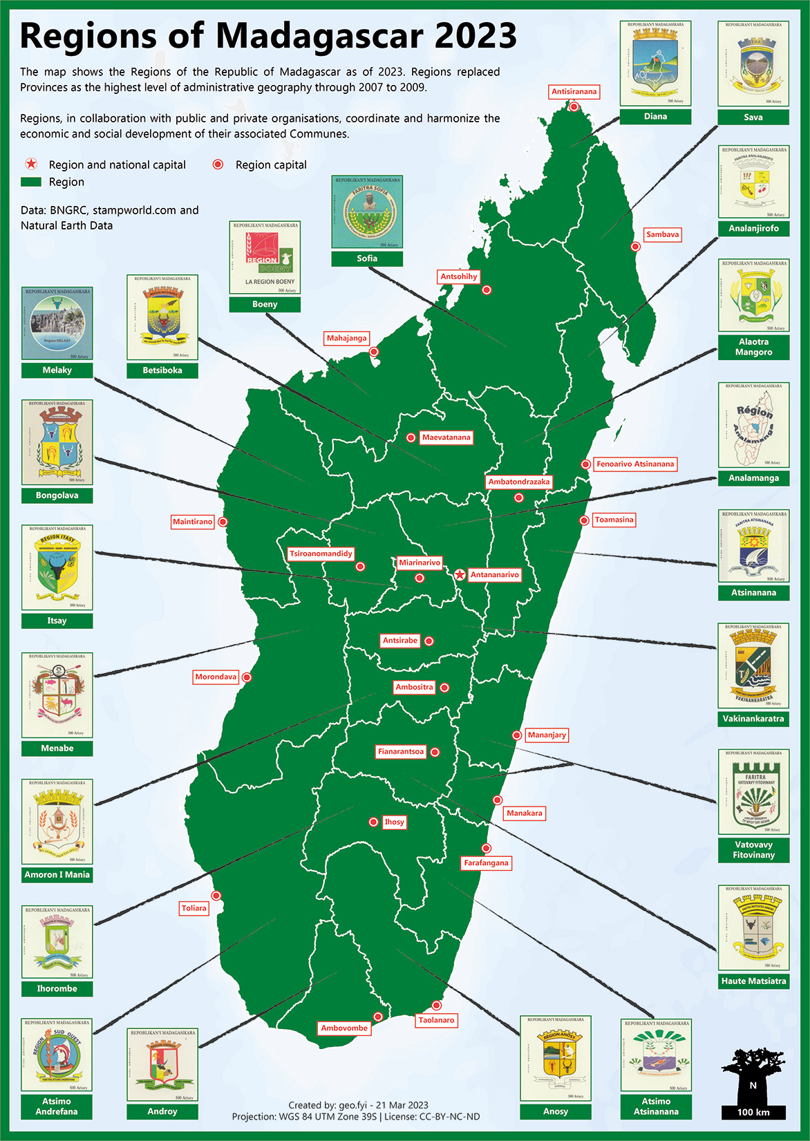
Regions (faritra)
Regions replaced Provinces as the highest level of administrative geography through 2007 to 2009.
“The Regions, in collaboration with public and private organisations, coordinate and harmonize the economic and social development of their associated Communes.”
Source: Constitution 2010.
| Date | Event |
|---|---|
| 26 Jan 1994 | Law 93-005 – “on the general orientation of the decentralization policy” – came into effect with the creation of 28 regions. |
| 03 Sep 2004 | Law 2004-001 came into effect with the creation of 22 regions to take over the assets of the ex-Fivondronampokontany. |
| 11 Aug 2021 | Vatovavy splits from Vatovavy Fitovinany to form the 23rd region with the town of Mananjary becoming the regional capital. See also here. |
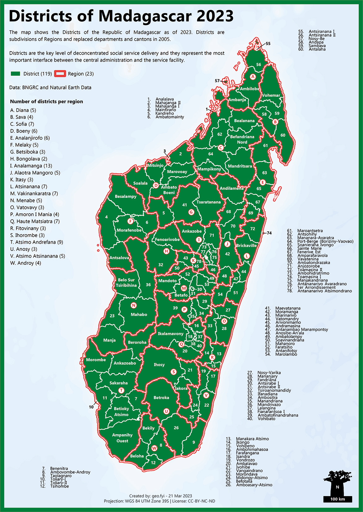
Districts (distrika)
Districts are subdivisions of Regions and replaced departments and cantons in 2005.
“They are the key level of deconcentrated social service delivery and they represent the most important interface between the central administration and the service facility.”
Source: World Bank.
| Date | Event |
|---|---|
| 26 Jan 1994 | Law 93-005 – “on the general orientation of the decentralization policy” – came into effect with the creation of more than 100 departments (fileovana) |
| 2004 | Term “designated components of the region” used in place of departments |
| 2005 | Presidential decree 2005-012 replaces departments with 116 Districts with the same boundaries as the old “Sous-préfectures” or ex-Fivondronampokontany. |
| 11 Aug 2021 | Mananjary, Nosy Varika and Ifanadiana form the districts of the new Region Votaovavy. Manakara, Vohipeno and Ikongo remain the districts of Fitovinany |
Communes (faribohitra/kaominina)
Communes came in to existence in 1994.
“Communes are the most basic component, created and delineated by law and have a geographic, economic, social and cultural homogeneity”
Source: Constitution 2010.

| Date | Event |
|---|---|
| 26 Jan 1994 | Law 93-005 – “on the general orientation of the decentralization policy” – came into effect with the creation of a little less than 1,000 Communes. |
| 26 May 1995 | Decree No. 95-381: Relating to the classification of Communes into urban Communes or rural municipalities |
| 26 Jan 2011 | Decree No. 2011-042: Relating to the classification of Communes into urban/rural Communes or in urban/rural municipalities |
| 27 Sep 2014 | Article 8 of Law No. 2014-020: Relating to the classification of Communes into urban/rural Communes or in urban/rural municipalities |
| 01 April 2015 | Decree No. 2015-592: Relating to the classification of Communes into urban/rural Communes or in urban/rural municipalities |
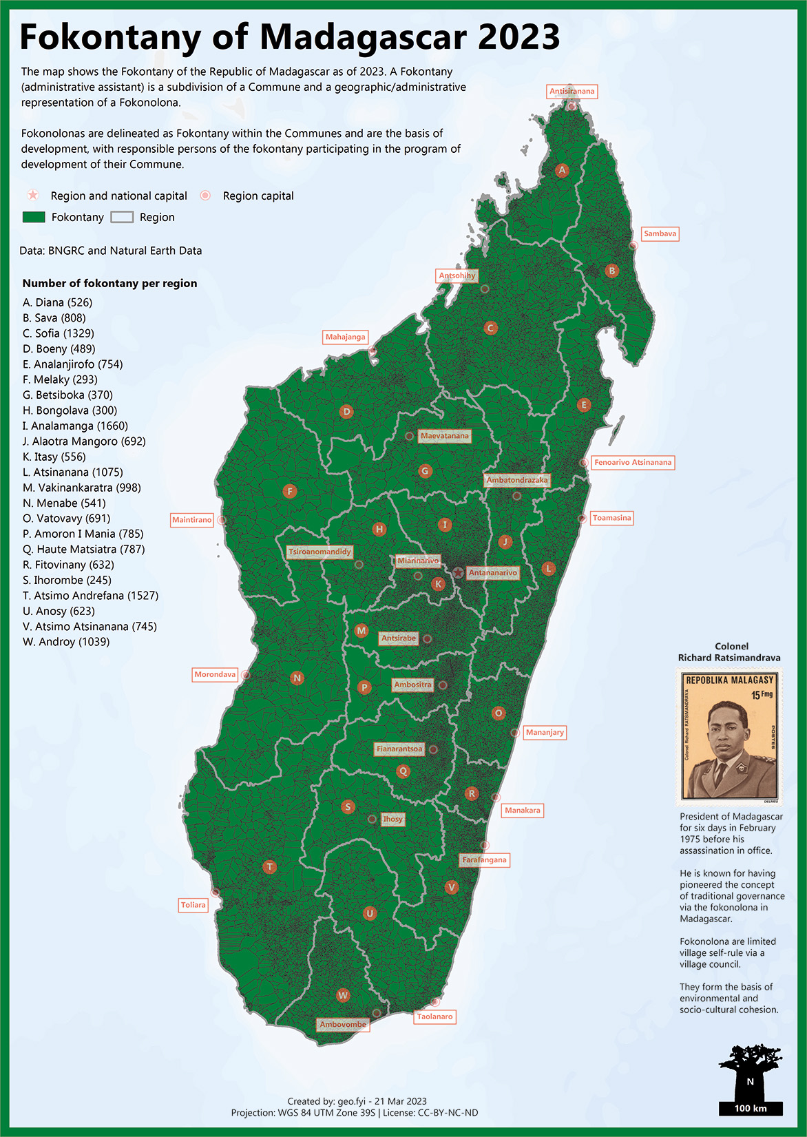
Fokontany and Fokonolonas
A Fokontany (administrative assistant) is a subdivision of a Commune and a geographic/administrative representation of a Fokonolona. They have no legal personality of their own.
“Fokonolonas are delineated as fokontany within the Communes and are the basis of development, with responsible persons of the fokontany participating in the program of development of their Commune.”
Source: Constitution 2010.
The Fokonolona, pioneered by Richard Ratsimandrava, is traditional governance via limited village self-rule and a village council. They form the basis of environmental and socio-cultural cohesion.
From Independence to Decentralized Territorial Collectivities
The table below summarises the journey of decentralisation taken by Madagascar’s administrative geography, from independence to the current system of Decentralised Territorial Collectivities.
| Years | Event |
|---|---|
| 1960 – 1974 | 1962 publication of the Code Official Geographique de Madagascar |
| 1975 – 1991 | Four levels of government: – Faritany (province) – Fivondronana (county or fivondronampokontany) – Firaisana (‘union of collectivities‘ or firaisampokontany) – Fokonolona (village or fokontany) |
| 1992 | Constitution of 1992 divides the nation into Decentralised Territorial Entities: – Region (faritra) – Department (departemanta) – Commune (kaominina) |
| 1998-2000 | 1998 revised Constitution transforms Provinces into Autonomous Provinces, with them coming into effect in 2000. |
| 2004 | Presidential Decree 2004-299 redefines the Fokontany (subdivision of Communes). |
| 2005 | The department replaced with the district |
| 2007 | Constitutional referendum replaces Provinces with Regions as the highest level of administrative geography. |
| 2009 | Six provinces formally dissolved. |
| 2010 | Constitution 2010 divides the nation into Decentralized Territorial Collectivities: – Provinces – Regions – Communes With a constitutional referendum held 17 November 2010. |
